|
|
Home >
Weather >
NZ Weather
 National Weather Summary
 |
| Dunedin |
| Tonight |
 |
Hi:
Low:
 |
18°
10°
5 |
Fine with 5kph WSW winds
|
|
|
|
For detailed forecast click here
|
|
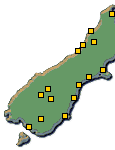 |
Move your mouse pointer
over towns for local
forecasts & click for details |
|
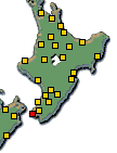 |
 
Click above for North
& South Island Weather |
| Tomorrow |
 |
Hi:
Low:
 |
21°
13°
|
| Partly Cloudy |
|
|
| Wednesday |
 |
Hi:
Low:
|
19°
12°
|
Showers
|
|
|
|
|
| National Short Range Summary |
|
|
Northland to Waitomo
Fine spells. Isolated showers developing in Northland tomorrow afternoon.
Coromandel Peninsula, Bay of Plenty and Taupo
Mainly fine, but isolated showers developing tomorrow morning, possibly heavy in the east tomorrow evening.
Gisborne and Hawke's Bay
Cloudy periods. Isolated showers clearing this evening, but returning north of Tolaga Bay tomorrow evening.
Taumarunui and Taihape to Wellington, including Wairarapa, also Marlborough and Nelson
Mostly fine.
Buller, Grey and Westland
Cloudy periods. Isolated showers about the Westland ranges, extending everywhere tomorrow evening.
Canterbury and Otago
Fine spells. Isolated showers tomorrow afternoon and evening.
Southland and Fiordland
Mostly cloudy with showers at times for Fiordland. Fine intervals for Southland, but a few showers there tomorrow.
Chatham Islands
A few showers, clearing to fine tomorrow.
click here for your national text summary and Long Range Forecast
|
Data is for information only. New Zealand City disclaims all liability or responsibility for any loss or damage that may result from the
action or failure to act by any person in reliance on any information provided herein.
All content © 2026 NZCity Ltd, data © 2026 MetService and other providers.
|
|
|